Tako malo več kot en mesec je preteklo od zadnje posodobitve. Sem malo zopet resno prijel za delo. Tokrat kar nekaj novosti. Norveška je izdala 1m resolucijo DTM, imamo 100% pokritost Jugozahoda Anglije, Avstralija je izdala v zadnjih letih v 1m in 2m resoluciji.
Dodal sem tudi link do portala OpenTopography, kjer najdete lahko veliko zanimivih stvari! Priporočam registracijo, saj so datoteke, ki jih lahko prenesete s tem večje....večje površine.
Link do seznama
-------------------------------------------------------------------------------------------------------------------------
One month later and new update. Some really interesting updates, for English users must check is 100% coverage of South West. Also new datasets of Malta, Norway and Australia.
I also added link to portal OpenTopography where you can access a lot of different LiDAR projects data around the World. I recommend registration as you can download bigger areas.
Link to list page
Prikaz objav z oznako LiDAR. Pokaži vse objave
Prikaz objav z oznako LiDAR. Pokaži vse objave
torek, 11. julij 2017

torek, 8. november 2016
List of freely accessible LiDAR data and digital terrain models
THIS LIST IS NOT UPDATED ANYMORE. I MOVED IT TO THIS SITE https://arheologijaslovenija.blogspot.co.uk/p/blog-page_81.html
Surveying surface of the Earth with LiDAR technology is increasing, thereby the database of LiDAR data is constantly increasing.
Surveying surface of the Earth with LiDAR technology is increasing, thereby the database of LiDAR data is constantly increasing.
And some
databases are openly available on the internet. In the vast majority
of a LiDAR surveys were and are undertaken by various government
agencies of various countries around the world. Openly available
LiDAR data in available in different formats, coordinate systems and
state of processing (from the cleaned point cloud data to the digital
terrain model of the ground).

On the internet you can find many different lists of digital terrain models of ground (DTM) and LiDAR data recording, but almost all receive an irregular update and are therefore deficient.
I encourage people to try different LiDAR data to try something new. In addition to new technical GIS knowledge you will gain it is also fun to discover new archaeological sites or view the famous archaeological sites from LiDAR “view” in other countries.
Conditions for making to the list are:
- free access to files
- files are already classified lidar data (files with the extension .LAS, .LAZ, .zLAS, .ASC, .XYZ)
- a digital terrain model of resolution 5m or less (files with the extension .GeoTIFF, .ASC, .IMAGE, .DEM)
!When ftp server is available use of ftp client is recommended. Here is guide how to setup open-source ftp client FileZilla.
I will check list monthly and update it regularly.
If you have any trouble getting data from internet sites on this list, leave a message on the comments and I'll help.
If you know the source I missed or it is brand new, leave a message in the comments and I'll be happy to check it in and add it to the list.
| Europe |
|---|
| Country | Region/City/State | Format | CRS/Koordinatni sistem | Particularities |
|---|---|---|---|---|
| Austria | Wien | GeoTIFF | EPSG:31256 | |
| Belgium | Wallonia | GeoTIFF | EPSG:31370 | Click on bold link Downloaden and pick file |
| Denmark | GeoTIFF | EPSG:25832 | Free registration needed | |
| England | ASCII-raster | EPSG:27700 | ||
| Finland | LAZ | EPSG:3067 | In datasets search LiDAR | |
| Germany | North Rhine-Westphalia | XZY-points | EPSG:25832 | Under DGM folder you can select DTM files |
| Germany | Thuringia | XZY/LAZ | EPSG:25832 | Search for place name and then click it to select 1x1km big quadrant |
| Italy | Bolzano, South Tyrol | GeoTIFF | EPSG:3044 | |
| Italy | Friuli-Venezia | ASCII-raster | EPSG:3044 | On right side search places |
| Italy | Trentino | ASCII-raster | EPSG:4326 | In the top row, click the icon cursor pointing to the cube |
| Spain | Basque | LAS | EPSG:25830 | |
| Luxemburg | ASCII | EPSG:2169 | Whole countrie in one file | |
| Netherland | GeoTIFF/LAZ | EPSG:28992 | AHN3 dataset | |
| Netherland | GeoTIFF | EPSG:28992 | AHN2 dataset | |
| Northern Ireland | ASCII-raster | EPSG:29901 | Check coverage map. | |
| Scotland | ASCII-raster | EPSG:27700 | Pick resolution, then under data resources click link. One big file. | |
| Slovenia | zLAS/LAZ | EPSG:25830 | ||
| Spain | LAZ | EPSG:4258 | Under municipio search place or municipy | |
| Spain | Catalonia | LAZ | EPSG:25830 | |
| Spain | La Rioja | LAZ/GeoTIFF | EPSG:25830 | Click on cartgrafia tematica and search lidar or modelo digital |
| Switzerland | Solothurn canton | LAZ/GeoTIFF | EPSG:21781 | |
| Switzerland | Zurich canton | LAZ/GeoTIFF | EPSG:2056 | In maps menu seek LiDAR |
| Wales | ASCII-raster | EPSG:27700 |
| North America |
|---|
| Country | Region/City/State | Format | CRS | Particularities |
|---|---|---|---|---|
| ZDA | Indiana | LAS/IMAGE-raster | EPSG:2965/2966 | In datasets the LiDAR in DEM files are under IndianaMap Data |
| ZDA | Kentucky | LAZ/IMAGE-raster | USER defined | Search LiDAR, select LiDAR or DTM, then click link to go to ftp server |
| ZDA | Louisiana | XZY/DEM-raster | EPSG:26915 | |
| ZDA | Minnesota | LAZ | See each dataset | Search by counties/ftp access |
| ZDA | North Dakota | LAS/XYZ/IMAGE-raster/ASCII-raster | EPSG:26914 | |
| ZDA | Ohio | LAS/ASCII-raster | EPSG:32122 | |
| ZDA | Washington | LAS/XYZ/IMAGE-raster/ASCII-raster | EPSG:Custom-is written in files | With tool for select region choose region and then choose data for download |
| Latin America and Caribbean |
|---|
| Country | Region/City/State | Format | CRS | Particularities |
|---|---|---|---|---|
| Haiti | LAS/ASCII-raster | EPSG:3857 |
| Oceania |
|---|
| Country | Region/City/State | Format | CRS | Particularities |
|---|---|---|---|---|
| New Zealand | LAZ/ASCII-points/GeoTIFF | EPSG:2193 | Click on wanted data set. Then click on Point cloud data. On next page use select region and then choose format of data for download |
nedelja, 6. november 2016
Seznam prosto dostopnih podatkov lidarskega snemanja in digitalnih modelov reliefa tal
TA BLOG ZAPIS NI VEČ AKTUALEN. PRESTAVLJENO NA STRAN https://arheologijaslovenija.blogspot.co.uk/p/blog-page_76.html
Snemanja zemeljskega površja s LiDAR tehnologijo se vedno bolj razširjajo, s tem pa se povečuje tudi baza lidarskih podatkov.
Snemanja zemeljskega površja s LiDAR tehnologijo se vedno bolj razširjajo, s tem pa se povečuje tudi baza lidarskih podatkov.
In kar nekaj jih je prosto dostopna
na internetu. V veliki večini gre za podatkovne baze lidarskih
snemanj, ki so jih opravile različne državne agencije posameznih
držav po celem svetu. Dostopni podatki so v različnih formatih,
koordinatnih sistemih in stanjih obdelave (od celostnih podatkov do
digitalnega modela reliefa tal).
Na spletu kroži veliko
raznih seznamov digitalnih modelov reliefa tal in podatkov lidarskega
snemanja, a so skoraj vsi deležni nerednega posodabljanja in zato
pomanjkljivi.
Poleg novega tehničnega
GIS znanja, ki ga s tem pridobimo, se je zabavno podati v druge
države in tam odkrivati nova arheološka najdišča ali pa si
ogledati znana arheološka najdišča iz lidarskega pogleda.
Pogoji za uvrstitev na
seznam so, da:
- je omogočen prost dostop do podatkov
- so klasificirani lidarski podatki/točkovni oblak (datoteke s končnico .LAS, .LAZ, .zLAS, .ASC, .XYZ)
- ima digitalni model reliefa resolucijo 5m ali manj (datoteke s končnico .GeoTIFF, .ASC, .IMAGE, .DEM)
!Ko je dostop omogočen preko ftp je priporočena uporaba ftp programa! Navodila, kako namestiti in uporabljati odprtokodni ftp program FileZilla.
Seznam bom mesečno
preverjal in posodabljal.
Če imate kakršne koli
težave pridobivanja podatkov iz internetnih strani na seznamu
pustite sporočilo pod komentarji in bom pomagal.
Če poznate še kakšen
vir, pustite sporočilo v komentarjih in z veseljem bom preveril in
dodal na seznam.
| Evropa |
|---|
| Država | Regija/Mesto/Pokrajina | Format | CRS/Koordinatni sistem | Posebnosti |
|---|---|---|---|---|
| Anglija | ASCII-raster | EPSG:27700 | ||
| Avstrija | Dunaj | GeoTIFF | EPSG:31256 | |
| Belgija | Valonija | GeoTIFF | EPSG:31370 | Klikni na link z odebeljenim Downloaden in izberi datoteko |
| Danska | GeoTIFF | EPSG:25832 | Potrebna brezplačna registracija | |
| Finska | LAZ | EPSG:3067 | Med dataseti išči LiDAR | |
| Italija | Bolzano, Južna Tirolska | GeoTIFF | EPSG:3044 | |
| Italija | Furlanija Julijska krajina | ASCII-raster | EPSG:3044 | Desno v meniju išči kraj |
| Italija | Trentino | ASCII-raster | EPSG:4326 | V zgornji vrstici klikni ikono kursorja ki kaže na kocko |
| Luxemburg | ASCII | EPSG:2169 | Cela država v enem kosu | |
| Nemčija | Severno Porenje-Vestfalija | XZY-points | EPSG:25832 | Pod DGM se nahajajo datoteke modela reliefa tal |
| Nemčija | Turingija | XZY/LAZ | EPSG:25832 | Išči kraj in klikni na kvadrat za prenos |
| Nizozemska | GeoTIFF/LAZ | EPSG:28992 | AHN3 dataset | |
| Nizozemska | GeoTIFF | EPSG:28992 | AHN2 dataset | |
| Severna Irska | ASCII-raster | EPSG:29901 | Poglej karto pokritosti. | |
| Slovenija | zLAS/LAZ | EPSG:25830 | ||
| Škotska | ASCII-raster | EPSG:27700 | Izberi ločljivost, nato pod data resources klikni link. | |
| Španija | LAZ | EPSG:4258 | Pod municipio išči po kraju | |
| Španija | Baskija | LAS | EPSG:25830 | |
| Španija | Katalonija | LAZ | EPSG:25830 | |
| Španija | La Rioja | LAZ/GeoTIFF | EPSG:25830 | Klikni na cartgrafia tematica in iščici lidar ali pa modelo digital |
| Švica | Solothurn kanton | LAZ/GeoTIFF | EPSG:21781 | |
| Švica | Zurich kanton | LAZ/GeoTIFF | EPSG:2056 | Med kartami išči LiDAR |
| Wales | ASCII-raster | EPSG:27700 |
| Severna Amerika |
|---|
| Država | Regija/Mesto/Zvezna država | Format | CRS/Koordinatni sistem | Posebnosti |
|---|---|---|---|---|
| ZDA | Indiana | LAS/IMAGE-raster | EPSG:2965/2966 | Med dataseti je LiDAR in DEM pod IndianaMap Data |
| ZDA | Kentucky | LAZ/IMAGE-raster | USER defined | Išči LiDAR, nato izberi in klikni link, ki ti odpre ftp |
| ZDA | Louisiana | XZY/DEM-raster | EPSG:26915 | |
| ZDA | Minnesota | LAZ | Odvisno od dataseta | Išči po posameznih pokrajinah/ftp dostop |
| ZDA | Ohio | LAS/ASCII-raster | EPSG:32122 | |
| ZDA | Severna Dakota | LAS/XYZ/IMAGE-raster/ASCII-raster | EPSG:26914 | |
| ZDA | Washington | LAS/XYZ/IMAGE-raster/ASCII-raster | EPSG:Custom-je zapisan v datotekah | Z orodjem za izbiro območja )tretja ikona la levi strani= izberi območje in nato željene podatke |
| Srednja Amerika in Karibi |
|---|
| Država | Regija/Mesto/Zvezna država | Format | CRS/Koordinatni sistem | Posebnosti |
|---|---|---|---|---|
| Haiti | LAS/ASCII-raster | EPSG:3857 |
| Oceanija |
|---|
| Država | Regija/Mesto/Zvezna država | Format | CRS/Koordinatni sistem | Posebnosti |
|---|---|---|---|---|
| Nova Zelandija | LAZ/ASCII-points/GeoTIFF | EPSG:2193 | Klikni na željen dataset. Klikni na Point cloud data. Tam z select region izberi področje in nato format podatkov |
sreda, 3. avgust 2016
#FridayLiDAR
In the beginning of my Twitter activity not so long ago, @MarkusZevnik suggested me a hashtag #FridayLiDAR when I started to post every Friday a LiDAR visualizations of interesting archaeological sites and landscapes.
Since in March 2016 I have managed to post quite a collection of a very interesting archaeological sites and landscapes. In this blog post I decided that i will make a list every now and then of all published #FridayLiDAR tweets.
Why LiDAR every week?
In Slovenia, we have publicly available data LiDAR recording for the total area of the country. This allows us a view of the shape of the surface, even where there is a forest ... and in Slovenia we have over 60% of land covered with forest.
LiDAR imagery reveal many new and unknown archeological sites. From better visible already known archaeological traces and sites to completely newly discovered and almost completely preserved archaeological landscapes and sites.
With LiDAR we have possibility to display in very easy and attractive way shape of landscapes and archaeological sites to the general public.
I also publish a LiDAR imagery of archaeological sites from other countries. Thus, in addition to Slovenia also from the UK, Finland and Italy. I have in plan few other countries...expect some surprise.
03/18/2016 - LiDAR imagery of an prehistoric hillfort Cvinger near Vir pri Stični/Slovenia.
04/01/2016 - LiDAR imagery of prehistoric and late Roman hillfort Ajdovščina in Brkini/Slovenia.
08/04/2016 - LiDAR imagery of iron age hillfort Ivigton Camp in Herefordshire/UK.
04/15/2016 - LiDAR imagery of prehistoric and late Roman hillfort and the medieval castle Šilentabor near Pivka/Slovenia.
04/22/2016 - LiDAR imagery of an hillfort V Lazu and in the surroundings pre-medieval field boundaries/Slovenia.
04/29/2016 - LiDAR imagery of pre-medieval field boundaries and possible plain settlement near village Vrhpolje-Kozina/Slovenia.
06/05/2016 - LiDAR imagery of pre-medieval field boundaries and possible plain settlement near village of Škocjan - Divača/Slovenia.
05/13/2016 -LiDAR imagery of an prehistoric hillfort in the village of Gradina Kosovelje in Karst/Slovenia.
05/20/2016 - LiDAR imagery of an prehistoric hillfort in the village of Birth Zagradec in Karst/Slovenia.
05/27/2016 - LiDAR recording of one the best preserved prehistoric hill forts in the Karst, Vahta in the village of Kazlje/Slovenia.
06/10/2016 - LiDAR imagery of an prehistoric hillfort Tabor near Vrabče and surrounding pre-medieval field boundaries/Slovenia.
06/17/2016 - LiDAR imagery of an prehistoric hillfort Debela Griža pri Kozini/Slovenia.
06/24/2016 - LiDAR imagery of two prehistoric hillforts above Newcastle-on-Clun in Shropshire / United Kingdom.
07/01/2016 - LiDAR imagery of an prehistoric hillfort Rapola/Finland.
08/07/2016 - LiDAR imagery of an prehistoric hillfort Žuškovka near village Laže-Senožeče/Slovenia.
07/15/2016 -LiDAR imagery of the early Roman military camp near Gročana/Italy.
07/22/2016 - LiDAR imagery of the wider surroundings of Newcastle-on-Clun in Shropshire. Transcription of prehistoric hillforts, burial mounds and the early medieval dikes/Great Britain.
07/29/2016 - LiDAR imagenry and transcription of archaeological traces pre-medieval field boundaries plain settlement in near village Naklo near Divača/Slovenia.
 |
| Hillfort Žuškovka - #FridayLidar of 07.08.2016 |
Why LiDAR every week?
In Slovenia, we have publicly available data LiDAR recording for the total area of the country. This allows us a view of the shape of the surface, even where there is a forest ... and in Slovenia we have over 60% of land covered with forest.
LiDAR imagery reveal many new and unknown archeological sites. From better visible already known archaeological traces and sites to completely newly discovered and almost completely preserved archaeological landscapes and sites.
With LiDAR we have possibility to display in very easy and attractive way shape of landscapes and archaeological sites to the general public.
I also publish a LiDAR imagery of archaeological sites from other countries. Thus, in addition to Slovenia also from the UK, Finland and Italy. I have in plan few other countries...expect some surprise.
03/18/2016 - LiDAR imagery of an prehistoric hillfort Cvinger near Vir pri Stični/Slovenia.
04/01/2016 - LiDAR imagery of prehistoric and late Roman hillfort Ajdovščina in Brkini/Slovenia.
08/04/2016 - LiDAR imagery of iron age hillfort Ivigton Camp in Herefordshire/UK.
04/15/2016 - LiDAR imagery of prehistoric and late Roman hillfort and the medieval castle Šilentabor near Pivka/Slovenia.
 |
| Šilentabor #FridayLiDAR of 15.04.2016 |
04/29/2016 - LiDAR imagery of pre-medieval field boundaries and possible plain settlement near village Vrhpolje-Kozina/Slovenia.
06/05/2016 - LiDAR imagery of pre-medieval field boundaries and possible plain settlement near village of Škocjan - Divača/Slovenia.
05/13/2016 -LiDAR imagery of an prehistoric hillfort in the village of Gradina Kosovelje in Karst/Slovenia.
05/20/2016 - LiDAR imagery of an prehistoric hillfort in the village of Birth Zagradec in Karst/Slovenia.
05/27/2016 - LiDAR recording of one the best preserved prehistoric hill forts in the Karst, Vahta in the village of Kazlje/Slovenia.
06/10/2016 - LiDAR imagery of an prehistoric hillfort Tabor near Vrabče and surrounding pre-medieval field boundaries/Slovenia.
06/17/2016 - LiDAR imagery of an prehistoric hillfort Debela Griža pri Kozini/Slovenia.
06/24/2016 - LiDAR imagery of two prehistoric hillforts above Newcastle-on-Clun in Shropshire / United Kingdom.
 |
| Two prehistoric hill forts above Newcastle-on-Clun #FridayLiDAR of 06.24.2016 |
08/07/2016 - LiDAR imagery of an prehistoric hillfort Žuškovka near village Laže-Senožeče/Slovenia.
07/15/2016 -LiDAR imagery of the early Roman military camp near Gročana/Italy.
07/22/2016 - LiDAR imagery of the wider surroundings of Newcastle-on-Clun in Shropshire. Transcription of prehistoric hillforts, burial mounds and the early medieval dikes/Great Britain.
07/29/2016 - LiDAR imagenry and transcription of archaeological traces pre-medieval field boundaries plain settlement in near village Naklo near Divača/Slovenia.
četrtek, 16. junij 2016
Hillfort Ajdovščina - Giant of Brkini hills
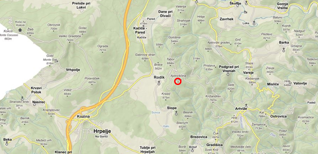
Ajdovščina
is a 804m high
hill that lies
above the village Rodik in the Hrpelje-Kozina municipality.
It is an end of
the central Brkini ridge
of the northern part of Brkini. Hill Ajdovščina has a very exposed
and dominant position in the landscape.
From it you can see far to
Karst region,
Vremščica hill,
on the crest of Slavnik ridge
and the Gulf of Trieste.
 |
| Location of hill Ajdovščina on a map (geoprostor.net) |
In archeology everything connected with Ajdi (placenames, folk traditions) are very important as an indicator of possible archaeological sites. To these giants folk tradition usually attribute origin or construction of larger visible and large structures in landscape, whether human made (hillforts) or natural (rocky walls).
In folk tradition Ajdi are referenced to the people who were "here" in the landscape before new settlers (Slavs) who are the carriers of giants Ajdi folk tradition.
On the hill Ajdovščina are still visible remains of massive walls, with gates and ruins the walls of individual houses. In the 80s and 90s the hillfort Ajdovščina was investigated by the Department of Archaeology of the Faculty of Arts in Ljubljana. They have conducted some surveys, small scale excavations and geophysical surveys.
 |
| Entrance to the hillfort Ajdovščina. On left and right are clearly visible the remains of Late Antiquity wall (photo: Jošt Hobič). |
 |
| LiDAR picture of hillfort Ajdovščina. Most of visible archaeological features are from Late Antiquity (author: Jošt Hobič). |
Oldest evidence of settlement on Ajdovščina is from early Iron Age (7th century BC). During excavation inside hillfort Ajdovščina they found fragments of pottery and cremation urn grave near road that leads to hillfort from early Iron age. Settlement of hillfort is likely to continue to the Roman period. For now we have evidence that hillfort was still occupied from 1st century BC to the 2nd century AD. Archaeologist found Roman pottery at the top area of hillfort. They were situated under a floor of late antique apse building. Outside the settlements they have discovered two cemetery’s where they excavated 19 graves all dated to Antiquity. After this period settlement is abandoned and possibly inhabitants relocate to of the valley.
 |
| One of the visible ruins of Late Antiquity house (photo: Jošt Hobič). |
 |
| Same house remains with lines of walls drawn (photo: Jošt Hobič). |
 |
| LiDAR map with location of house. Click to see it better (author: Jošt Hobič). |
During Late Antiquity they strengthen the walls and gates and set the houses that are aligned in a street system and along the wall.
At the top of the hill during the excavations archaeologist found a building with an apse. Such a semicircular completion of the building, usually in Late Antiquity hillfort settlements indicates the early Christian church. But here on the basis of the findings such church could not be confirmed yet.
In Late Antiquity, Ajdovščina, due to the dominant position and close proximity to the Roman state road Aquileia - Tharsatica running through Matarsko valley, acted as control of these road connections to Italy. Therefore we can expect it had permanent military garrison.
For the period of the Early Middle Ages (from 7th to 9th century AD) and Slavic settlement Ajdovščina was one of the centers in the surrounding area of Romanized indigenous people who still lived here. Despite the absence of archaeological finds, this is assumed on the basis of the interpretative model of the folk tradition and some historical writen evidences.
Literature
Hrobat, K. 2003,
Šembilja na rimskih cestah. O ustnem izročilu in arheoloških
raziskavah, diplomsko delo, oddelek za arheologijo FF, Ljubljana.
Pavlin, P. 2014,
Ajdovščina nad Rodikom, v: Kras in Brkini za radovedneže in
ljubitelje, ur. Fakin Bajec J. In Luthar O., ZRC SAZU, Ljubljan –
Nova Gorica.
Mušič, B. 1999,
Geophysical prospecting in Slovenia: an overwiev with some
observations related to natural enviroment, Arheološki vestnik 50,
349-405. Link to article (its in English)
Naročite se na:
Objave (Atom)